
Along the Gold Coast and Towards Sydney
Leaving Brisbane felt first like going back to the big blue and it's vast emptyness or sometimes also loneliness. With good northerlies we sailed down to Peel Island. Surprise, the anchorage hosted over thirty boats ... it was the week end and Birsbanian boaties were all out in Moreton Bay. Yacht racing on the horizon, we sailed slowly in the shallows. But that was just the start.
There are two options to get south: through the Broadwater or heading north, out of Moreton Bay and then turning south in the open water. As we had done enough blue water sailing we decided to take the inland route: a network of sandy streams and mangrove lined islands. As in Moreton Bay, depths were very limited. The charts on the chart plotter as well as local guides show depths from 4-30ft. A powerline right in the middle of the distance to cover - clearance unclear. Some guides say 23.5m, exactly our air draft, others say 20.5m, bot enough to go below. So good planning was essential.
Departing from Peel Island we sailed downwind with 3kts boatspeed, followed by another sailor just leaving the anchorage. Zig-zagging towards the channels, we started monitoring the depth sounder regularly. Depths charted were 6.6ft to 9.6ft, so already an opportunity to run aground. Carefully choosing our path and well following the buoyage, we slowly progressed south. We did go slow on purpose. As we did not know the areas and were aware that sand is quickly changing depths we did not fully trust the charts. The sailboat behind first fell back, but then overtook as we switched to staysail and even lower speeds to go accross 6-9ft shallows. Why did we take the risk? Because be had the incoming tide with us, so we always kept 5ft of water below the keel. Only at one point it went to 3ft below the keel, still way more than the "Handbreit" required. Not to mention it was stressfull - narrow channels, traffice, minimal water below the keel added up.
Reaching the Rocky Point powerline we found official clearance in the middle at 66ft. Tired from the sailing we dropped anchor after checking the tide. We would try it tomorrow in the morning if at all. With internet research we found what we had heard before: close to the pylon clearance was said 29m. While 29m seems like the hight of the lowest cable, some safety margin to avoid electric shocks from the high voltage lines was certainly needed. Another ship of our size had crossed at high tide, we planned to go under it at rising tide. So fingers' crossed we went to bed for a not so restfull night.
Isa at the mast and under engine we approache the pylon early next morning. We had found a photo of a Discovery 55 passing the pylon, a boat that's exactly our size. So with confidence we approached. Isa having a close eye on the top, I steered close to the pylon while keeping track of the depth. Luckily, the chart was understating the depth. So with a little tide we had 8ft below the keel, safe to cross. Isa did not shout, so we drifted closer and closer until I saw the cables above my head: we passed with enough air in between. Quickly I turned back to the center of the channel on the other side of the powerline, to avoid more shallows.
Happily we motored farther south. Along mangroves first, then more and more homes and moored boats. Our other challenge approached also: two areas charted at 3ft-6.6ft. Guess what, we arrived at high tide. Adding the tidal water we got over the first shallow with 3ft at a minimum. It was not easy to find the right track, but studying the area and the markers we seem to have found the best spot. For the second shallow we as usual went slow. With 10ft water we went 5kts, with 8ft dropped to 4kts and all below 5ft we went between 2-3kts so we would not ground to heavy while still having enough water flow at the rudder to precisely control the vessel.
The chart identified two possible passes. Both only manageable for us at high tide. One marked, the other recommended as track. When we arrived, the buoyage was different. So we decided to follow the buoy instead of the chart - the chart was certainly more outdated. Slowly we progressed towards the deeper area. And made it accross in 6ft water. Surprise, the sands had shifted to our favor and the buoyage was up to date. Good luck and good planning, presumably. We did not accelerate much, though, as ahead was a junction of narrow channels. These were certainly dredged, so depth was not so much a concern but finding the right way through the maze of buoys. It was easy, as it turned out. Chart and buoyage were pretty in line, just the buoys were a little differently placed. So we cruised on through mangroves and small settlements.
Several nature reserves lined the river until we got into the busier part of this leg: the Gold Coast got close. High rises and villas appeared in the distance, soon. Oversize motor yachts speed through channels into the main channel. Hidden away marinas showed up on the chart plotter. Jet skies and other toys cluttered the water. And soon we had the high rises on our starbord side. Quickly we decided to anchor as long as there was still mangrove on our port side. It was an exciting but tiring passage from Moreton Bay to the Gold Coast and we needed a rest.
Btw: The "Gold Coast" at Lake Zurich may go a long, long way to reach that density of villas and high rises. However, the Gold Coast in QLD will never have the fresh water access with sorrowless hopping into the water - too many creatures here advise for carefull plunging only.
Impressions from sailing Moreton Bay southwards into the Gold Coast.
Gold Coast seems to be Disney Land for retirees and families on holiday. Maybe we are wrong, and that’s not the case. But to use this is what came across. So we did not want to spend too much time there. A walk on the sandy spit, the quiet side of the Gold Coast, and a visit into Southport to get some veggies was all to do. Of course we also had a nice cappuccino in town. Gold Coast surprised us with a tram line (street car) and again nice parks. But overall the charming places and density we saw in Brisbane lacked. So we walked the Marine Stadium, just north of Sea World and exclusivities like Versace Mall, which is the other side of the sandy spit. It is kept as a park, with overgrown dunes and lovely jogging tracks. After the morning coffee at 0545 I ended up trying my legs on one of these. A good idea, but poor result. We wanted to sail on, anyway, but wind was SE - while we needed to go south, with the first part SSE.
Forecast were 20kts max, with waves at 2.1m at 7s. Not the conditions you want, not „on your nose“. However, in Jade Akka we trust and our desire to go south encouraged us to take some strain. And it did. We saw up to 27kts true, we went 6-8kts, so the short steep waves plus the apparent wind up to 30kts gaves us „a hard beating“. When sailing these conditions for a while it gets OK. But after sailing the narrow, shallow channels we were just not used to it anymore. So we decided to do one tack and see how things would go. Currents of 4kts flow south along this coast. That’s why the waves were short and steep in a southerly wind. But at least they should help us getting southwards, too. With mixed feelings we kept going on, expecting the wind to turn and weaken. But until then, we crahsed into waves, bangs echoed through the hull like we hit stone, water splashed aside from the bow, waves rolled over the anchor and splashed up to the pilot house. A nasty wave hit us right on the side, the spray going down the open companionway. Not only for the progress we had mixed feelings. The material got a test, and we tried to keep it as soft as possible by optimizing every bit of reefed sail, so it would not vibrate. Well reefed we still made up to 8.5kts - hitting waves rocked Jade Akka and left us wondering how that would feel in plastic boats (or yoghurt cups, as we call it for fun).
With the approaching evening we got closer to shore again. As expected, the wind turned weak, so we tacked earlier than expected to go back into the more windy areas off shore. Waves were down from 2.1m to 1m in the forecast, and we assume this was pretty precise. Comfortably we made our way back out to do a last tack for the day before starting the watch cycle.
At night the wind weakened further, leaving us to barely drift southwards. Sails reefed to avoid slatting we relied on the current to take us along. It worked out well and provided the crew with an OK rest. However, in the morning the wind was gone. As our water was going low we had to run the watermaker and thus did not mind motoring a few hours. Within 5 hours we were close to Yamba, our next bar to cross. To get more water, we drifted while waiting for slack tide to enter the bar. Late afternoon the conditions were good to pass. So we switched off the watermaker, got the engine running again and headed into the pass. Little chop but still quite a current made us pay good attention while slowly progressing into the river. Again, sands and depths made it difficult. Not worth running any extra risk we simply dropped anchor seemingly in the middle of the river - of course well away from the shipping route.
Saturday night probably is the best time to see Yamba. People are out and in the center of town. Like in any big country, the towns spread quite a bit. We dinghied to the yacht club, tied up, and walked a mile to get into town. We found an excellent French inspired restaurant which served beautifully dressed dishes. With a nice digestive walk we headed back through this clean and proper town. Next day we watched all the small boats on the river while having a yummy breakfast on board: avocado and prosciutto on toast with a poached egg. Of course the Italian coffee did not miss, too. So we relax today before heading on south. A short "rainforest walk" and beach exploration plus exploring Iluka will be today's distraction.
From Yamba we left for Port Macquarie. But with good northerly wind and convenient sailing, we made it too early and passed it at midnight. So we decided to go on to Port Stephens directly. Port Macquaries bar has a bad reputation, so we would have ahad to wait for high tide. Not expecting Port Macquarie to differ much from Yamba or Port Stephens the decision was easy to go on. The other, from a bar perspective potentailly better, option would have been Camden, but given the good wind we just wanted to go on.
The night passed and winds diminished, as usual I am tempted to say. In the early morning we were down to staysail, drifting. To have favorable currents entering into Port Stephens we decided to motor. High tide was 1500, so we did not want to be late. The forecast had indicated winds turning from north to south with that no-wind-zone passing us inbetween. So we were not too surprised to find ourselfes motoring into wind after just a few hours. Headsails up we kept going, making it into the bay just at high tide. Perfect timing. Now it's time to check out Port Stephens, before continuing towards Sydney where we will end our journey.
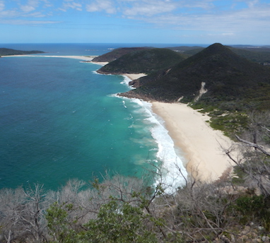
Port Stephens is a big bay, surrounded by hills and plains with typical Australian vegetation. Two lookouts provide great views (Nelson Bay and at the head). Fame Cove provides secluded anchorage. Nelson Bay and Port Stephens provide services of typical Australian high quality. To celebrate Isa's birthday, we went "fine dining" and spent a bit. The food was great, superbly spiced, lovely presented and service very professional. Yeah, we did not do something like that for years! Being in fast internet country again left us staring into the screens as if we were at home or at work. We have a lot to catch up :-) And we also have to organize a few things for the job, for the boat and for a new home. So time passed quickly and soon we headed out again to sail to Broken Bay.
Leaving Port Stephen we had 20-25kts from the back, from the land side and thus no big waves. We hardly felt any movement but faintly heard the gargling water passing Jade Akka's hull. As so often along this coast the wind died in the early morning hours and we were left adrift, just hanging the staysail out to stabilize a bit. And of course a few hours later the wind came back. So we made the 70nm in 10 hours, dirfted into Broken Bay, sailed into Pitwater and finally had to motor to the anchorage. After we had dropped anchor in little wind we enjoyed breakfast. Scrambled eggs and avocado added to sudden gusts of 30kts. Knowing the nachor would hold, we went to sleep to compensate for the watch time.
Many cruisers sell their boats here in Broken Bay. So we will see Pacific friends here that are in process of selling and also do nice walks in the Ku-Ring-Gai Chase NP. Sadly we will also try to meet one of the brokers to see what to do with Jade Akka ... as for now, we hope to live a few weeks on board once working in Sydney while searching for permanent housing. Then, later in the Australian winter or following spring we will decide on our boating future.
There are two options to get south: through the Broadwater or heading north, out of Moreton Bay and then turning south in the open water. As we had done enough blue water sailing we decided to take the inland route: a network of sandy streams and mangrove lined islands. As in Moreton Bay, depths were very limited. The charts on the chart plotter as well as local guides show depths from 4-30ft. A powerline right in the middle of the distance to cover - clearance unclear. Some guides say 23.5m, exactly our air draft, others say 20.5m, bot enough to go below. So good planning was essential.
Departing from Peel Island we sailed downwind with 3kts boatspeed, followed by another sailor just leaving the anchorage. Zig-zagging towards the channels, we started monitoring the depth sounder regularly. Depths charted were 6.6ft to 9.6ft, so already an opportunity to run aground. Carefully choosing our path and well following the buoyage, we slowly progressed south. We did go slow on purpose. As we did not know the areas and were aware that sand is quickly changing depths we did not fully trust the charts. The sailboat behind first fell back, but then overtook as we switched to staysail and even lower speeds to go accross 6-9ft shallows. Why did we take the risk? Because be had the incoming tide with us, so we always kept 5ft of water below the keel. Only at one point it went to 3ft below the keel, still way more than the "Handbreit" required. Not to mention it was stressfull - narrow channels, traffice, minimal water below the keel added up.
Reaching the Rocky Point powerline we found official clearance in the middle at 66ft. Tired from the sailing we dropped anchor after checking the tide. We would try it tomorrow in the morning if at all. With internet research we found what we had heard before: close to the pylon clearance was said 29m. While 29m seems like the hight of the lowest cable, some safety margin to avoid electric shocks from the high voltage lines was certainly needed. Another ship of our size had crossed at high tide, we planned to go under it at rising tide. So fingers' crossed we went to bed for a not so restfull night.
Isa at the mast and under engine we approache the pylon early next morning. We had found a photo of a Discovery 55 passing the pylon, a boat that's exactly our size. So with confidence we approached. Isa having a close eye on the top, I steered close to the pylon while keeping track of the depth. Luckily, the chart was understating the depth. So with a little tide we had 8ft below the keel, safe to cross. Isa did not shout, so we drifted closer and closer until I saw the cables above my head: we passed with enough air in between. Quickly I turned back to the center of the channel on the other side of the powerline, to avoid more shallows.
Happily we motored farther south. Along mangroves first, then more and more homes and moored boats. Our other challenge approached also: two areas charted at 3ft-6.6ft. Guess what, we arrived at high tide. Adding the tidal water we got over the first shallow with 3ft at a minimum. It was not easy to find the right track, but studying the area and the markers we seem to have found the best spot. For the second shallow we as usual went slow. With 10ft water we went 5kts, with 8ft dropped to 4kts and all below 5ft we went between 2-3kts so we would not ground to heavy while still having enough water flow at the rudder to precisely control the vessel.
The chart identified two possible passes. Both only manageable for us at high tide. One marked, the other recommended as track. When we arrived, the buoyage was different. So we decided to follow the buoy instead of the chart - the chart was certainly more outdated. Slowly we progressed towards the deeper area. And made it accross in 6ft water. Surprise, the sands had shifted to our favor and the buoyage was up to date. Good luck and good planning, presumably. We did not accelerate much, though, as ahead was a junction of narrow channels. These were certainly dredged, so depth was not so much a concern but finding the right way through the maze of buoys. It was easy, as it turned out. Chart and buoyage were pretty in line, just the buoys were a little differently placed. So we cruised on through mangroves and small settlements.
Several nature reserves lined the river until we got into the busier part of this leg: the Gold Coast got close. High rises and villas appeared in the distance, soon. Oversize motor yachts speed through channels into the main channel. Hidden away marinas showed up on the chart plotter. Jet skies and other toys cluttered the water. And soon we had the high rises on our starbord side. Quickly we decided to anchor as long as there was still mangrove on our port side. It was an exciting but tiring passage from Moreton Bay to the Gold Coast and we needed a rest.
Btw: The "Gold Coast" at Lake Zurich may go a long, long way to reach that density of villas and high rises. However, the Gold Coast in QLD will never have the fresh water access with sorrowless hopping into the water - too many creatures here advise for carefull plunging only.
Impressions from sailing Moreton Bay southwards into the Gold Coast.
Gold Coast seems to be Disney Land for retirees and families on holiday. Maybe we are wrong, and that’s not the case. But to use this is what came across. So we did not want to spend too much time there. A walk on the sandy spit, the quiet side of the Gold Coast, and a visit into Southport to get some veggies was all to do. Of course we also had a nice cappuccino in town. Gold Coast surprised us with a tram line (street car) and again nice parks. But overall the charming places and density we saw in Brisbane lacked. So we walked the Marine Stadium, just north of Sea World and exclusivities like Versace Mall, which is the other side of the sandy spit. It is kept as a park, with overgrown dunes and lovely jogging tracks. After the morning coffee at 0545 I ended up trying my legs on one of these. A good idea, but poor result. We wanted to sail on, anyway, but wind was SE - while we needed to go south, with the first part SSE.
Forecast were 20kts max, with waves at 2.1m at 7s. Not the conditions you want, not „on your nose“. However, in Jade Akka we trust and our desire to go south encouraged us to take some strain. And it did. We saw up to 27kts true, we went 6-8kts, so the short steep waves plus the apparent wind up to 30kts gaves us „a hard beating“. When sailing these conditions for a while it gets OK. But after sailing the narrow, shallow channels we were just not used to it anymore. So we decided to do one tack and see how things would go. Currents of 4kts flow south along this coast. That’s why the waves were short and steep in a southerly wind. But at least they should help us getting southwards, too. With mixed feelings we kept going on, expecting the wind to turn and weaken. But until then, we crahsed into waves, bangs echoed through the hull like we hit stone, water splashed aside from the bow, waves rolled over the anchor and splashed up to the pilot house. A nasty wave hit us right on the side, the spray going down the open companionway. Not only for the progress we had mixed feelings. The material got a test, and we tried to keep it as soft as possible by optimizing every bit of reefed sail, so it would not vibrate. Well reefed we still made up to 8.5kts - hitting waves rocked Jade Akka and left us wondering how that would feel in plastic boats (or yoghurt cups, as we call it for fun).
With the approaching evening we got closer to shore again. As expected, the wind turned weak, so we tacked earlier than expected to go back into the more windy areas off shore. Waves were down from 2.1m to 1m in the forecast, and we assume this was pretty precise. Comfortably we made our way back out to do a last tack for the day before starting the watch cycle.
At night the wind weakened further, leaving us to barely drift southwards. Sails reefed to avoid slatting we relied on the current to take us along. It worked out well and provided the crew with an OK rest. However, in the morning the wind was gone. As our water was going low we had to run the watermaker and thus did not mind motoring a few hours. Within 5 hours we were close to Yamba, our next bar to cross. To get more water, we drifted while waiting for slack tide to enter the bar. Late afternoon the conditions were good to pass. So we switched off the watermaker, got the engine running again and headed into the pass. Little chop but still quite a current made us pay good attention while slowly progressing into the river. Again, sands and depths made it difficult. Not worth running any extra risk we simply dropped anchor seemingly in the middle of the river - of course well away from the shipping route.
Saturday night probably is the best time to see Yamba. People are out and in the center of town. Like in any big country, the towns spread quite a bit. We dinghied to the yacht club, tied up, and walked a mile to get into town. We found an excellent French inspired restaurant which served beautifully dressed dishes. With a nice digestive walk we headed back through this clean and proper town. Next day we watched all the small boats on the river while having a yummy breakfast on board: avocado and prosciutto on toast with a poached egg. Of course the Italian coffee did not miss, too. So we relax today before heading on south. A short "rainforest walk" and beach exploration plus exploring Iluka will be today's distraction.
From Yamba we left for Port Macquarie. But with good northerly wind and convenient sailing, we made it too early and passed it at midnight. So we decided to go on to Port Stephens directly. Port Macquaries bar has a bad reputation, so we would have ahad to wait for high tide. Not expecting Port Macquarie to differ much from Yamba or Port Stephens the decision was easy to go on. The other, from a bar perspective potentailly better, option would have been Camden, but given the good wind we just wanted to go on.
The night passed and winds diminished, as usual I am tempted to say. In the early morning we were down to staysail, drifting. To have favorable currents entering into Port Stephens we decided to motor. High tide was 1500, so we did not want to be late. The forecast had indicated winds turning from north to south with that no-wind-zone passing us inbetween. So we were not too surprised to find ourselfes motoring into wind after just a few hours. Headsails up we kept going, making it into the bay just at high tide. Perfect timing. Now it's time to check out Port Stephens, before continuing towards Sydney where we will end our journey.
Port Stephens is a big bay, surrounded by hills and plains with typical Australian vegetation. Two lookouts provide great views (Nelson Bay and at the head). Fame Cove provides secluded anchorage. Nelson Bay and Port Stephens provide services of typical Australian high quality. To celebrate Isa's birthday, we went "fine dining" and spent a bit. The food was great, superbly spiced, lovely presented and service very professional. Yeah, we did not do something like that for years! Being in fast internet country again left us staring into the screens as if we were at home or at work. We have a lot to catch up :-) And we also have to organize a few things for the job, for the boat and for a new home. So time passed quickly and soon we headed out again to sail to Broken Bay.
Leaving Port Stephen we had 20-25kts from the back, from the land side and thus no big waves. We hardly felt any movement but faintly heard the gargling water passing Jade Akka's hull. As so often along this coast the wind died in the early morning hours and we were left adrift, just hanging the staysail out to stabilize a bit. And of course a few hours later the wind came back. So we made the 70nm in 10 hours, dirfted into Broken Bay, sailed into Pitwater and finally had to motor to the anchorage. After we had dropped anchor in little wind we enjoyed breakfast. Scrambled eggs and avocado added to sudden gusts of 30kts. Knowing the nachor would hold, we went to sleep to compensate for the watch time.
Many cruisers sell their boats here in Broken Bay. So we will see Pacific friends here that are in process of selling and also do nice walks in the Ku-Ring-Gai Chase NP. Sadly we will also try to meet one of the brokers to see what to do with Jade Akka ... as for now, we hope to live a few weeks on board once working in Sydney while searching for permanent housing. Then, later in the Australian winter or following spring we will decide on our boating future.